
Every teacher looks for ways to make learning “stick” and many will agree that hands-on lessons are the most unforgettable. The Gibbes Museum of Art has a portable kit called Create-A-Map that is totally hands-on, and it’s available for schools to use. With Create-A-Map, learning about South Carolina is fun, educational, and, most of all, memorable.
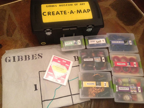
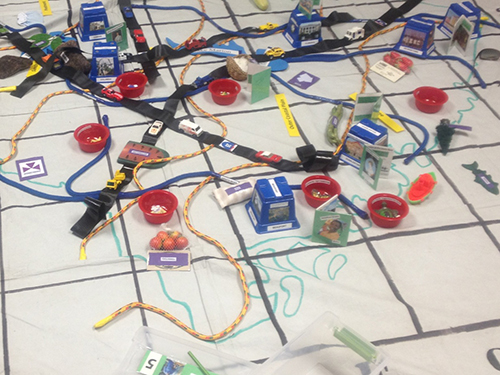
Create-A-Map allows students to construct a 9×12 foot, three dimensional map of South Carolina right on their classroom floor. The base is a large canvas floor cloth with the outline of the state and a numbered and lettered grid drawn on it to help guide the placement of cities, rivers, products, etc. Participants are divided into seven “teams” and for each team there is a small map for reference and a box of items to place on the floor map.
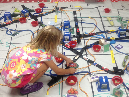
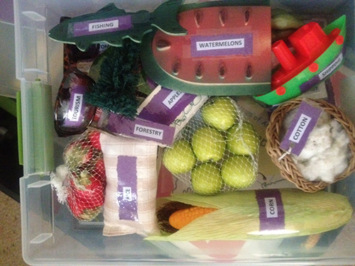
The “Cities” Team has nine plastic cups, labeled with city names and covered with artwork and photos, to place on the grid. The “Rivers and Lakes” Team uses blue ropes and foam-board lakes. “Interstate Highways” are represented with long black strips affixed with Matchbox cars. The “Regions” Team divides the state with yellow ropes, and then adds labels, bean-bag mountains, and sandhills to the floor map. “Products” (a tiny basket of cotton, strawberries, a toy boat for shipping, etc.), “State Symbols” (a piece of blue granite, a plastic spotted salamander, etc.), and “People” representing famous South Carolina citizens (each represented with a small scrapbook), round out the teams. The map can be assembled in about an hour, and when it’s finished, it’s loaded with information that can foster discussions and further study. The map was an idea that began as an outdoor project at the museum more than fifteen years ago. Using the back patio of the museum as the grid, student visitors built an enormous South Carolina map right in the courtyard. The next step in its development was to make a travelling kit that would fit in a classroom, and Create-A-Map was born.
Over the years the kit has been used by many schools and has been revised several times. This year the museum asked me to refurbish Create-A-Map, bring it up-to-date with school standards and technology, and streamline it for easier use. I’ve always been a big fan of the kit because it combines social studies, geography, history, mapping skills, art appreciation, problem-solving, and teamwork! It was my pleasure to tweak it for 2013.
Those of you who have used the kit before might notice some changes. I added the outline of South Carolina directly to the floor cloth so students wouldn’t have to lay out the border with a rope (which never stayed put!). I added a team for famous South Carolinians and made a tiny “scrapbook” to represent each of the ten people. I reworked the regions team to comply with the SC standards. The instructions and team boxes have been streamlined so now the entire kit fits into one rolling bin (2’6” x 1’6” x 1’2”).
The new kit is complete and ready to go! Reserve it for your classroom by contacting Rebecca Sailor at the Gibbes Museum by phone, 843-722-2706 x41, or via email at [email protected]. We would love your feedback, and we hope you enjoy the new and improved Create-A-Map!
—Mary Droge, Gibbes Museum Educator and guest blogger
Published August 21, 2013